鸟瞰中国
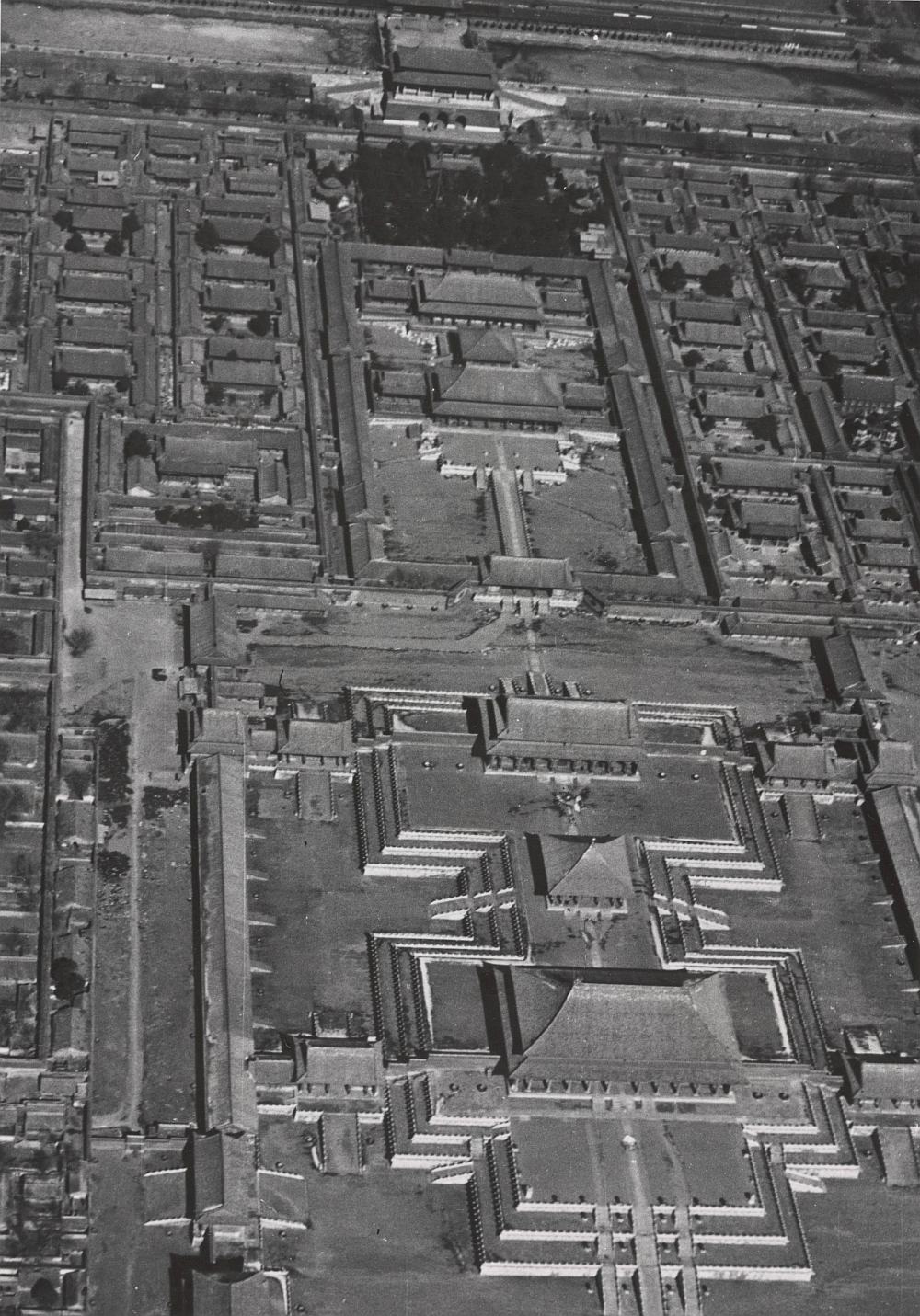
此《Ground and Aerial Views of China》系列由民国时期一名德国飞行员 J. P. Koster 拍摄。此套含照片 533 幅,大部分是从北京到包头、宁夏、兰州、西宁、西安、郑州到上海和汉口、长沙、广州以及西安到昆明成都的航线上拍摄。这些照片大致拍摄于 1940 年前。
其内照片多为中国各地的风景纪实(多为航拍), 其中一幅为手绘紫禁城布局 [1]。英文图录大致如下:
图 1 至图 23:Canton. 约 1940 年
图 24 至图 29:Chengtu. 约 1940 年
图 30 至图 63:Forbidden City.aerial view. 约 1940 年
图 64 至图 86:Fortified villages inhabited.partly abandoned.or abandoned through drought or bandit extermination. 约 1940 年
图 87 至图 93:Hankow. 约 1940 年
图 94 至图 128:Hankow-Changsha-Hengyang-Chenhsien. 约 1940 年
图 129 至图 157:Hua-shan.Liupan-shan.Honan scenes. 约 1940 年
图 158:Hua-shan mountains and Huang-ho valley. 约 1940 年
图 159 至图 173:Huang-ho.Lanchow to Ningsia. 约 1940 年
图 174 至图 198:Hunan.between Chengchow and Sian. 约 1940 年
图 199 至图 201:Kuo-tzu chien. 约 1940 年
图 202 至图 230:Kwangtung Province. 约 1940 年
图 231 至图 248:Lanchow city.Huang-ho valley.loess mountains. 约 1940 年
图 249 至图 287:Lanchow and vicinity. 约 1940 年
图 288 至图 310:Loess terraces and canyons northwest of Liupan-shan. 约 1940 年
图 311 至图 331:Ming tombs.Western Hills.Peking. 约 1940 年
图 332 至图 334:Mongol graves near Ningsia. 约 1940 年
图 335 至图 362:Ningsia city.Ordos desert. 约 1940 年
图 363 至图 366:Pagodas in Kunming. 约 1940 年
图 367 至图 384:Paoto city and monastery.Suiyuan. 约 1940 年
图 385 至图 401:Peking. 约 1940 年
图 402 至图 409:Pi-yun ss.Western Hills.Peking. 约 1940 年
图 410 至图 418:Shanghai to Nanking. 约 1940 年
图 419 至图 436:Sian to Chengtu and beyond. 约 1940 年
图 437 至图 458:Sian-fu. 约 1940 年
图 459 至图 467:Sining. 约 1940 年
图 468 至图 498:Sining.Panchen Lama and Tibetan nobility. 约 1940 年
图 499 至图 513:Summer Palace.Peking. 约 1940 年
图 514 至图 530:Temple and Altar of Heaven.etc. 约 1940 年
图 531:Terraced loess mountains. 约 1940 年
图 532、图 533:Yung-ho Kung. 约 1940 年[hide] 鸟瞰中国.Ground and Aerial Views of China.摄影BY J. P. Koster.约1940年.pdf: http://share.czqixidi.com/f/33324767-810436656-66ba58
[/hide]